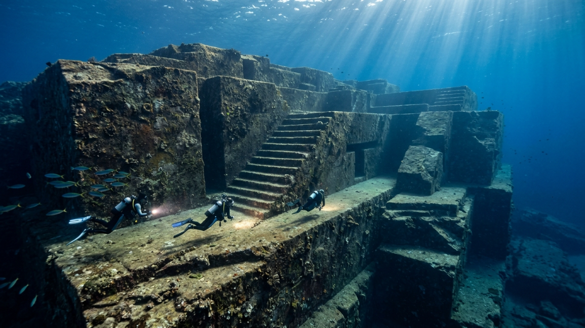
Lying just off the coast of Japan’s southernmost Ryukyu Islands, a massive, submerged stone structure challenges our entire understanding of post-glacial history. Discovered by a diver in 1986, the Yonaguni Monument is a colossal sandstone formation measuring over 490 feet long and 80 feet tall. The structure features sweeping stepped terraces, perfectly flat plazas, straight vertical walls, and sharp right angles that mimic an ancient, grand amphitheater. For decades, researchers have been locked in a fierce debate: is this an entirely natural formation shaped by tectonic fracturing and ocean currents, or is it a monolithic, rock-cut structure carved by a lost ice-age civilization before being swallowed by rising sea levels at the end of the last major glacial period? By stripping away the sensationalism and conducting a strict structural audit, a close look at the Yonaguni Monument anomaly reveals an incredible interaction between natural geology and deliberate human modifications.
What makes this underwater site an exceptional focus for maritime engineering is how its physical traits diverge from standard marine erosion. By analyzing the structural patterns of its twin megaliths, the precise orientation of its straight trenches, and the presence of tool-like markings, marine archaeologists are mapping out the true origin of this sunken marvel.
1. Parallel Fracturing Tolerances vs. Precise Right Angles
The primary argument for a natural origin is that sandstone naturally fractures along clean, straight bedding planes, creating blocky shapes known as orthogonal jointing. Wave action and strong underwater currents can erode these fractures over thousands of years, leaving behind sharp, stepped profiles.
However, when marine geologists conducted an architectural audit of the main terrace layout, they discovered structural traits that defy random wave erosion.
While natural jointing creates straight lines, it rarely produces perfectly intersecting 90-degree internal corners across multiple levels. At Yonaguni, the stepped platforms feature uniform vertical drops that meet flat floors at precise right angles. The dimensional consistency across these stone steps mirrors the structural precision found in the Puma Punku stone blocks engineering matrix, where fixed templates were used to guide construction. The presence of multiple clean, intersecting angles sitting right next to completely unfractured, smooth stone faces suggests the site was manually shaped rather than randomly broken apart by the sea.
2. The Isolation of the Twin Megaliths
On the upper platform of the monument sit two immense, vertical sandstone blocks positioned side by side. Known as the Twin Megaliths, these upright structures stand over 6 feet tall and feature perfectly flat, parallel faces separated by a narrow, clear gap.
From a geological standpoint, if these blocks were formed entirely by tectonic shifting, matching fragments of stone debris should be scattered across the immediate seafloor.
Instead, the surrounding rock platform has been completely cleared of loose stone material. The bases of the Twin Megaliths meet the flat floor at a clean junction, showing zero signs of natural tearing or tearing scars. This layout suggests that the blocks were intentionally left standing while the surrounding stone was carved out and cleared away. This specialized technique of removing stone to leave behind a free-standing structure matches the design logic uncovered in our Derinkuyu underground city engineering analysis, where massive columns were carved out of solid rock to support the ceiling.
.
📊 Structural Properties of the Ryukyu Sunken Terrace
| Structural Asset | Physical Condition Discovered | Primary Scientific Implication | Impact on the Target Timeline |
| Main Terraced Steps | Sharp 90-degree angles; uniform vertical drops | Suggests deliberate manual carving over natural erosion | Challenges standard post-glacial timelines |
| The Loop Road | Clear, continuous channel encircling the monument base | Functioned as a low-friction transport or drainage path | Establishes planned layout design across the site |
| Twin Megaliths | Two upright vertical stones with parallel faces | Left standing deliberately while surrounding stone was cleared | Proves advanced knowledge of rock-cut masonry |
3. The Linear Geometry of the Loop Road Channel
Encircling the entire base of the Yonaguni Monument anomaly is a distinct, continuous stone channel known as the Loop Road. This feature is a wide, flat pathway bounded by a straight vertical wall on one side and a raised stone lip on the other.
If this channel were a natural product of underwater cross-currents, the water flow would erode the stone unevenly, polishing the corners into soft, rounded curves over thousands of years.
Instead, the channel maintains a completely uniform width and a perfectly flat bottom along its entire path. The vertical stone wall runs in a straight line, completely ignoring the natural wavy grain of the sandstone layers. This layout points to a highly functional, human-designed pathway. Prehistoric builders likely carved this channel out to act as either a secure, low-friction transport track to move materials around the structure, or as a massive surface drainage ditch built to channel heavy rainfall away from the foundation before the entire island was submerged by rising sea levels.
4. Tool-Marking Taphonomy and Star-Shaped Pitted Depressions
The most compelling proof of manual modification on the sunken terraces is the discovery of small, localized surface markings that cannot be explained by marine erosion or animal activity.
Scattered across the upper platforms are series of small, uniform, star-shaped depressions and deep, round holes measuring several inches across. Marine biologists have verified that these markings are completely different from the irregular holes bored by rock-eating clams or sea urchins.
Under close magnification, the internal walls of these holes show clear signs of mechanical chipping and crushing, indicating they were formed using hard, pointed tools like chisels or wedges. These rows of holes are arranged in straight lines along the edges of the stone blocks. This layout indicates that ancient masons used a classic plug-and-feather technique: they bored holes into the stone, drove wedges inside, and struck them to cleanly split off massive slabs of rock, leaving behind the flat terraces we see today.
5. Eustatic Sea-Level Timelines and Post-Glacial Submersion
To find out exactly when the monument was out of the water, marine scientists look at eustatic sea-level charts, which track how global ocean levels rose as the last ice age ended.
During the Last Glacial Maximum, massive amounts of the Earth’s water were locked up in giant ice sheets, keeping ocean levels more than 390 feet lower than they are today. The plateau where the monument sits was fully exposed to the open air between 10,000 and 12,000 years ago.
As the global climate warmed rapidly around 10,000 BC, melting ice sheets triggered a massive rise in sea levels, completely drowning the Ryukyu land bridges under deep ocean water. The pristine condition of the monument’s sharp edges is a direct result of this fast underwater preservation. Once the site was completely submerged beneath the wave action zone, it was perfectly protected from the harsh erosion of wind, rain, and surface storms, freezing the ancient stone architecture in time for millennia.
The Logistical Verdict on the Sunken Monument
The underwater terraces of Japan stand as a brilliant example of early human adaptation and rock-cut architecture. As this investigation into the Yonaguni Monument anomaly proves, the site is neither a basic natural rock formation nor a myth from science fiction.
Instead, it represents a natural sandstone formation that was extensively modified, carved, and reshaped by an advanced prehistoric society before being swallowed by the ocean at the end of the Last Glacial Maximum. By working with the natural jointing lines of the rock, these ancient builders carved out a monumental terrace system that survived thousands of years under the sea. The site remains an undeniable reminder that human history is deeply tied to the shifting cycles of our planet, matching the incredible preservation we see in other ancient locations like the Maltese megalithic temples.
🔍 High-Authority Academic Context Verification
-
To audit the official geological and oceanographic sea-level mapping data for the post-glacial Ryukyu island chain, review the University of Tokyo’s Atmosphere and Ocean Research Institute Data.
-
For an exhaustive breakdown of marine archaeological survey methods used on submerged monoliths, consult the NOAA Office of Ocean Exploration and Research Database.