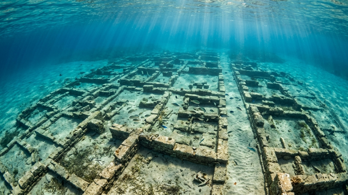
Submerged beneath just a few meters of water in the Peloponnese region of southern Greece lies a breathtaking structural achievement that completely alters our timeline of early Mediterranean seafaring. Discovered and mapped by oceanographers in 1967, the Pavlopetri sunken city is the oldest fully submerged archaeological port city ever found on Earth. Dating back over 5,000 years to the Early Bronze Age, the site is not a random collection of washed-away ruins; it is a meticulously planned urban center spanning over 100,000 square meters. The ruins feature a rigid grid layout of multi-room stone houses, distinct courtyards, paved main streets, and complex water-management channels. By stripping away local myths of sudden cataclysms and applying modern marine engineering forensics, researchers are uncovering the highly calculated maritime infrastructure built into this underwater metropolis.
What makes this Greek site an exceptional focus for maritime archaeology is how perfectly preserved its urban floor plan remains beneath the waves. By shifting away from romanticized folklore and examining the physics of wave erosion, the structural mapping of its stone foundations, and the presence of localized fault lines, marine geologists are tracking the true history of the Pavlopetri sunken city blueprint.
1. The Geometry of the Bronze Age Orthogonal Urban Grid
The primary diagnostic feature that shocks visitors to the Pavlopetri sunken city is the presence of an incredibly advanced, pre-planned urban layout. Unlike many early surface cities that grew randomly over generations, this port city was mapped out before construction began.
The underwater ruins reveal straight, parallel streets lined with identical, rectangular stone foundations.
Marine archaeologists utilizing side-scan sonar have mapped at least 15 separate, large multi-room buildings, complete with central courtyards and structured storage wings. This geometric consistency proves that the prehistoric builders used precise measuring lines to maintain fixed property boundaries across multiple city blocks. This level of intentional urban design mirrors the architectural planning found in our Yonaguni Monument anomaly guides, showing that prehistoric coastal societies relied on rigid structural layouts long before the rise of classic empires.
2. Advanced Hydro-Engineering and Intramural Water Channels
A critical operational requirement for keeping a dense, bustling trading port healthy and functional is a reliable system to manage fresh water and human waste.
A thorough underwater audit of the Pavlopetri sunken city ruins revealed a highly sophisticated network of hand-carved stone gutters, stone conduits, and drainage channels running alongside the main streets.
Catchment points capture surface runoff from multi-room stone houses.
The builders cut these narrow channels straight into the limestone blocks, angling the slopes downward toward the open shoreline. This design leveraged natural gravity to flush raw sewage out of the residential zones while safely funneling heavy seasonal rainfall away from the building foundations. This smart use of gravity-driven fluid dynamics matches the advanced environmental control care we see in our Derinkuyu underground city engineering analysis networks, proving that ancient societies treated infrastructure as a vital phase of construction.
📊 Maritime Infrastructure and Architectural Integrity Matrix
| Architectural Asset | Submerged Condition Discovered | Core Engineering Value | Impact on the Pavlopetri sunken city |
| Paved Main Streets | Wide tracks made of packed, fitted local fieldstones | Facilitated low-friction transport of heavy trading cargo | Confirms the site functioned as a high-velocity merchant hub |
| Intramural Channels | Sloped limestone gutters cut alongside property lines | Utilizes gravity to drive continuous sanitation flushing | Documented earliest regional use of urban waste management |
| Cist Tombs | Stone-lined box graves cut directly beneath house floors | Specialized structural burial vaults integrated into foundations | Highlights complex social and spiritual layout planning |
3. Storage Logistics and the Pithos Jar Fragments
The Pavlopetri sunken city was built from the ground up to serve as a massive, high-velocity trading hub linking early Aegean civilizations. To maintain this status, the city’s warehouses had to secure large amounts of valuable trade goods from moisture and pests.
Scattered across the floor plans of the largest buildings, divers recovered hundreds of fragments of massive, thick-walled ceramic storage vessels known as pithoi.
These giant clay jars stood over five feet tall and were engineered to hold hundreds of gallons of olive oil, wine, grain, and imported metals. The walls of the storage rooms were built extra thick using dense local stones to keep the internal rooms at a cool, constant temperature, protecting the valuable trade assets from spoiling in the intense Mediterranean heat. This focused approach to storage logistics highlights a highly organized merchant society that completely understood the science of environmental preservation.
4. Taphonomic Preservation and the Shallow-Water Wave Shield
A major geological question surrounding the site is how a 5,000-year-old city sitting in shallow water survived for millennia without being completely smashed to pieces by the pounding waves.
The answer relies on a unique feature of local marine taphonomy. The Pavlopetri sunken city sits inside a highly protected, shallow bay sheltered by a natural offshore ridge of rock.
This natural barrier functions exactly like a modern industrial breakwater. It catches and absorbs the immense energy of deep-sea winter storms before the heavy waves can reach the shoreline. Because the water inside the bay remains relatively calm, the stone foundations were never exposed to high-velocity underwater grinding. Instead, a gentle, continuous current slowly covered the ruins in a protective blanket of fine marine sand, perfectly freezing the ancient Bronze Age architecture in place like a time capsule. This natural shielding process matches the preservation factors we see in the Bimini Road anomaly sheets, where local marine environments prevented natural erosion from destroying historical evidence.
5. Holocene Tectonic Faulting and the Submersion Event
The final clue to solving the mystery of the Pavlopetri sunken city involves mapping out the exact geological disaster that sent this sprawling port to the bottom of the sea.
Unlike sites that were slowly submerged by global ice-age sea level rises over thousands of years, Pavlopetri was drowned suddenly by tectonic activity.
The Peloponnese coastline sits directly on an active tectonic plate boundary prone to severe, violent earthquakes. Geological surveys show that around 1000 BC, a series of massive structural faults slipped simultaneously, causing the entire coastal shelf to drop straight down by nearly 15 feet in a process known as co-seismic subsidence. The sea rushed in instantly, completely swallowing the docks, warehouses, and homes in a matter of minutes. This fast drop pulled the city safely beneath the active surface wave-destruction zone, protecting its incredible layout from human recycling and surface erosion for thousands of years.
The Logistical Verdict on the Submerged Port
The sprawling underwater foundations of Greece stand as an undeniable monument to prehistoric urban planning and maritime engineering. As this investigation into the Pavlopetri sunken city proves, this site does not require alternative history legends or lost empires to explain its existence.
Instead, it is an authentic, beautifully preserved Bronze Age port city that was abruptly dropped to the seafloor by local tectonic faulting 3,000 years ago. By applying standard marine archaeology, studying the layout of its sloped drainage channels, and mapping its protective sand taphonomy, modern science has opened a flawless window into our early maritime history. The site remains a timeless reminder of human ingenuity, matching the calculated care we observe in other historic puzzles like the Maltese megalithic temples.
🔍 High-Authority Academic Context Verification
-
To audit the official digital sonar maps and 3D virtual reconstructions of the Greek harbor ruins, see the University of Nottingham’s Pavlopetri Underwater Archaeology Project.
-
For an exhaustive look at co-seismic subsidence and tectonic shifting across the Peloponnese coast, consult the Hellenic Centre for Marine Research (HCMR) Database.